Story by Rick Kemmerer
Off-road Grand Canyon trip.
If you’re like me, like off-roading and enjoy site seeing then do I have a fun trip for you, off-road to the north rim area of Arizona’s Grand Canyon. This is a trip that required a street legal vehicle. Most of the trip can be made mild to moderate off-roading. We did this family adventure in a mostly stock Toyota Sequoia and a Toyota FJ Cruiser with my wife, my friend and his wife and daughter.
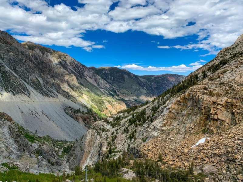
The trip started at about 9am and left from St George, Utah and ended about 9pm in Kanab, Utah. It was a long trip but well worth it. The first stretch is about 78 miles on a BLM fire road (#1069/ Co Hwy 5). We passed many old and current ranches and even saw a replica of an old area school house in old Bundyville. Continuing straight onto Co Hwy 257 after the school house, we dropped into Whitmore Meadows. At the bottom of the valley, we passed the Bar 10 guest ranch, followed by a small rocky  section for about 12 miles to the first destination of the Grand Canyon rim called Whitmore Meadows river overlook. The overlook is about half way down the Grand Canyon wall, but you can drive right to the edge. There is a trail down to the Colorado River and has area for tent camping (permit required).
Leaving toward the second rim stop called Tuweep, we took the trail back the last 12 miles just traveled. After 12 miles back up the valley, just past Bar 10 there is a T in the road, left or straight. Choosing left will take you back to the school house, where you will turn right (East on Co Hwy 5) and precede up to Mt Trumbull. We chose to try the other route, going straight at the T which will also get you to Mt Trumbull by going up and  over Mt Logan. The trail is about 14 miles long and included some advanced off-roading. There were many obstacles in the trail, tight brush, loose rock, steep switch backs and fallen trees on this trail. For the people that don’t like scratches on their vehicles, or are not confident with their trucks or skills I wouldn’t go this way. Once you reach the crest of the mountain, you will have to navigate the various and numerous unmarked trails. A GPS with topo maps, or trail maps would have been helpful… Our GPS did not have the trails marked, so we took a few dead end wrong turns. Watching for the “most traveled” trail markings and having way points marked will lead you out. We met up with the Mt Trumbull road about half way up the mountain road, and proceeded East on co
  hwy 5. At the base of Mt Trumbull road, turn right (South) towards Tuweep on Co Hwy 115.
Tuweep is one of the original spots that tourist were taken to look at the Grand Canyon on the north rim. It is an easy dirt road, until a few miles after the Tuweep ranger station, where you will encounter silt and some sandstone rock base. This overlook is higher than Whitmore Meadows, and has many ledges you can walk out onto that you can look back at the wall. Walking out on these ledges is not for the faint of heart. There is also an established camp site area at Tuweep, which no permit is required.
Leaving Tuweep, to get back to civilization, we traveled back up co hwy 115 to the Mt Trumbull intersection. Continue straight  (North) onto Co Hwy 5. About 5-6 miles after the Mt Trumbull intersection will be Co Hwy 109/5 “Y”. Either way is a 50 mile section of maintained dirt road, and will lead you back to main Highway 389. Hwy 5 will lead you closer to St George area, Hwy 109 will lead you closer to Kanab.
For those who have seen the Grand Canyon from both the south side and the north rim like I have, this is definitely worth doing. The views are amazing and we might have encountered 5 people going to the first rim and maybe another 10 at the second rim. This trip is a must do for people that like the Grand Canyon and like driving off-road. The families enjoyed the many different views we experienced, amazing colors and many animal spottings, including dear, coyote, lots of cows, and birds.
GPS Coords:
School house at Bundyville: 36°24’42.98″N 113°19’31.04″W
Bar 10 Guest Ranch: 36°16’31.51″N 113°13’59.29″W
Whitmore Meadows Overlook: 36° 9’4.08″N 113°12’18.52″W
Mt Trumbull: 36°23’30.77″N 113° 9’5.33″W
Tuweep Ranger: 36°17’10.91″N 113° 3’51.74″W
Tuweep overlook: 36°12’57.05″N 113° 3’21.85″W


5 comments
Thank you for a fantastic site. Found it on Google. Over the past 30 years I have had a lot of fun in my 4×4. There’s nothing like a day offroad. I spent a bit of time having a look around and will be back again soon.
We are looking at doing this trip in about a month, but figure we only have time for one overlook, if you had to choose, which one was your favorite (factoring in the off-roading experience to get to each)?
[…] Help with Grand Canyon area wheeling, camping, and hiking North Rim trip I did Grand Canyon North Rim, the hard way. | Toy Hauler Adventures 2007 Titanium 4×4 AT M.O.R.E. #3030 – Class 3000 Racing Horse Power = How Fast You Hit the […]
[…] some old thread info… i would delete this, but since i dont see how, here's a good link: Grand Canyon North Rim, the hard way. | Toy Hauler Adventures My 2010 Black FJ 4X4 build page | Deft Racing SPECTRE Hood | ICON Stage5 | LEVEL8 Wheels […]
[…] Full story on Toy Hauler Adventures; Photos by yours truly, Story by my best friend Rick: […]